
Easily Measure Distance and Area with Google Map on Android
![]() Updated on
Updated on
Do you know that you can calculate the distance between two or more points on the map? Well, Google Earth is getting a new Measure tool that will let you measure the distance and area of things on the map. With the tool, users can measure the distance between two points or the surface area of a selected chunk of the map.
For example, now you can finally find out how far your house is from your favorite beach. And don’t you imagine that you are limited to simple squares. The Measure tool gives you the chance to select the borders of an area so it’s easier to measure irregularly shaped objects like parks, buildings, or even states and countries.
This measurement will never be one hundred percent accurate, but it is still a good measure for those who want to get an approximate measurement of a property area or the distance between two spots on a region. And for your convenience, you can do all these by using the Google Map app straight on your Android device.
Let me show you how simple it can be:
How to Measure Distance and Area with Google Map on Android:
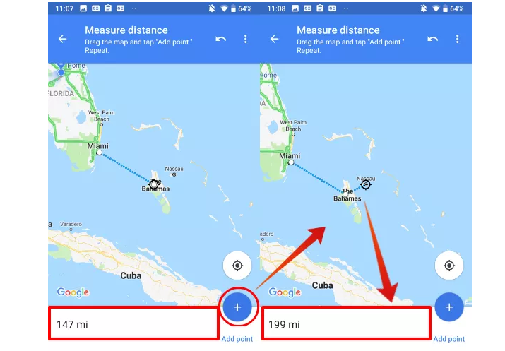
- To go ahead, you have to open the Google Map app on your tablet or smartphone;
- Touch and hold anywhere on the map. You’ll see a red pin appear;
- At the bottom, tap the name of the place;
- On the place’s page, scroll down and choose Measure distance;
- In order to add the next point or points, move the map so that the black circle, or crosshairs, is on the next point you want to add;
- At the bottom right, tap Add;
- Add points until you’re done;
- Then, at the bottom, you’ll see the total distance in miles (mi) or in kilometers (km);
- If you want to remove the last point you added, tap Undo. And in order to clear all points, just tap More More and then Clear;
- When done, just tap the back arrow in the top left.

Improve this guide


User forum
0 messages