
Learn to Measure Distances in Google Maps for Running, Biking, or Hiking
![]() 2 min. read
2 min. read
![]() Published on
Published on
Share this article

Improve this guide
Google Maps makes navigating your world faster than ever before and you know that there are no compromises when it comes to Google. Your beloved Google Maps offers satellite imagery, street maps, as well as 360° real-time traffic conditions (Google Traffic), panoramic views of streets, along with route planning for traveling by foot, car, or public transportation.
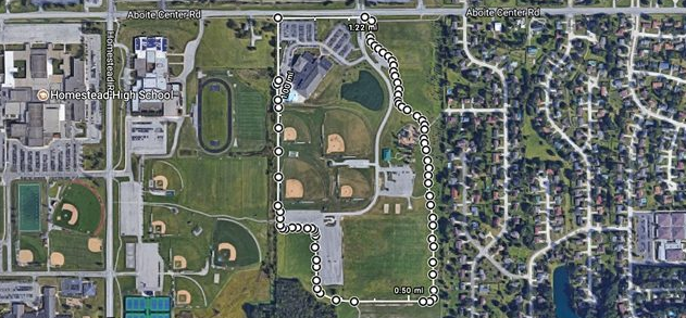
If your wish is to know the precise distance between point A and point B while running, biking, or hiking, be sure that you can do that in Google Maps.
After all, getting directions in Google Maps lets you easily see how far away the destination is and makes you feel in control all the time. In such conditions, I see no reason for not using this feature on your own Android device too.
You may also like: New Q&As Feature for Google Maps and search
Learn to Measure Distances in Google Maps for Running, Biking, or Hiking:
- Go to maps.google.com;
- Tap on the starting point where you want the distance measurement to begin;
- Then choose the option that says Measure Distance;
- From there, follow the trail and click on it wherever it curves so that the measuring markers follow the trail’s path exactly;
- You can zoom in and out as much as you want during the process;
- You also have the possibility to see the total distance so far at the bottom, as well as the total square footage of the area if you are making a complete circuit;
- If you want to delete a point, simply just click on it to remove it;
- When it comes to adding points, do that anywhere along the line and then, feel free to drag them around to change the path.
Do not hesitate to: Track Your Friends with the Help of Google Maps or to Share Directions from Google Maps


User forum
0 messages